Indigenous · History Classes · Grades 10–13 · College · University
The Mapping of the World — How the Earth Got onto Paper
History Class · Level band: Grades 10–13 · College · University
English edition — the language editions of the history classes are outstanding and will follow the site’s translation pattern; none is fabricated here.
§1 — WHY THIS CLASS CLOSES THE VOLUME
DOCUMENTED — the method, stated first. Every class in this strand has worked from documents, and the hardest documents to read are maps — because a map looks like a picture of the earth, and is not. A period map is a portrait of its maker’s knowledge: its coastlines are only as good as the reports behind them, its colours are a geographer’s conveniences, and its blank or decorated corners are evidence too — of what its maker did not know, or had only been told. Read that way, five centuries of maps become a history of knowledge itself: what each age knew, what it drew wrong in good faith, and how the wrong was corrected — in the open, on the next sheet. This class walks that history once, end to end, and then stops: the reading skill it teaches is the one the whole volume has used.
§2 — KNOWLEDGE GATHERED FROM SAILORS: THE PORTOLANS AND THE CATALAN ATLAS
DOCUMENTED. The first accurate coastlines of the European Middle Ages were not drawn in libraries. They were drawn from the working knowledge of sailors. The portolan chart — named for the written book of sailing directions — plotted the Mediterranean and Black Sea coasts harbour by harbour, with rhumb lines radiating from compass roses so a captain could read off a course. Portolan coastlines are startlingly right where sailors actually sailed, because they were compiled from thousands of voyages’ bearings and distances; inland, where no sailor’s knowledge ran, the same charts are thin. A portolan is a portrait of a working knowledge: exact at the water’s edge, vague a week’s march inland.
DOCUMENTED. The supreme work of the tradition is the Catalan Atlas of 1375, made at Palma, Majorca, and attributed to Cresques Abraham, a Jewish cartographer and illuminator working with his son in the Majorcan school, for the Aragonese court; it passed as a royal gift to the king of France. Majorca stood where the knowledge routes crossed — Christian, Muslim and Jewish learning, Catalan shipping, and the reports coming back along the trade roads from Asia — and the atlas is what that crossing produced. Its Mediterranean is the sailors’ sea, drawn from use. Its West Africa carries the gold world of Mali, its king enthroned with a gold nugget. Its Asia is drawn from the travellers, above all Marco Polo: the caravan road east, the cities of Cathay in rows, the Great Khan enthroned — and at the far edges the things report carried but knowledge had not tested: Gog and Magog penned behind Alexander’s wall. The atlas does not hide the join between what was sailed, what was walked, and what was only told. That join is the state of knowledge in 1375, drawn by the best workshop in Europe.
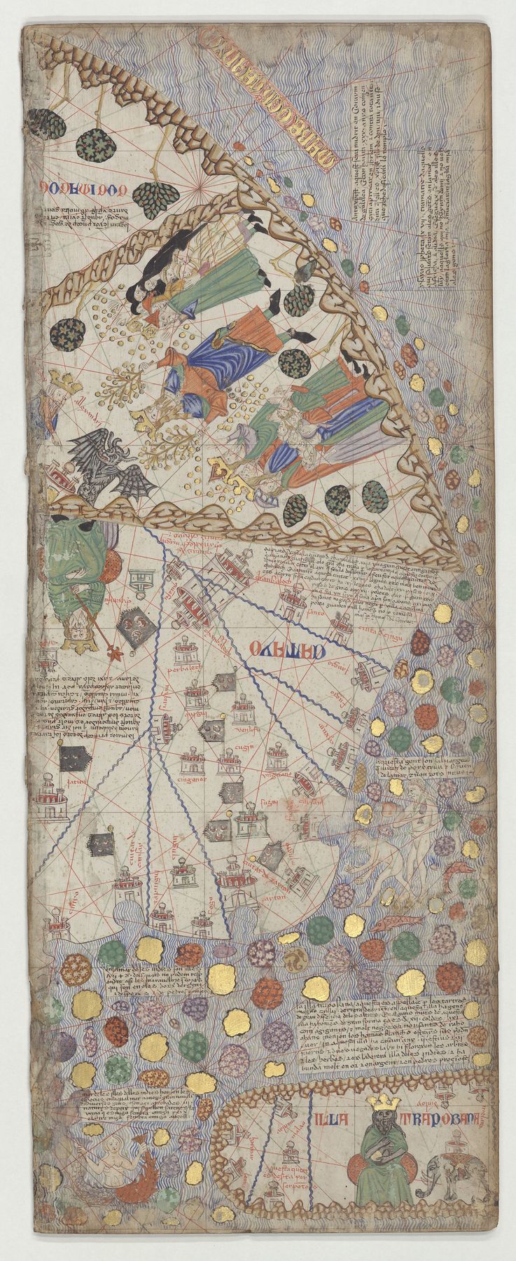
1 · The Catalan Atlas — the eastern panel (Cathay and the Great Khan).
Maker: attributed to Cresques Abraham, Palma, Majorca · Date: 1375; the sheet reproduced here is the atlas’s easternmost panel (sheet 12) as held and scanned by its holding library; the atlas is oriented with south at the top, and the scan keeps the holding’s orientation · Title: Atlas catalan (the Catalan Atlas), eastern panel · Source: Bibliothèque nationale de France (Gallica, btv1b55002481n), via Wikimedia Commons — public domain, verified on the file page, 2026-10-28.
What it shows: the Mongol world as Majorca knew it in 1375 — Cathay lettered across the panel in rows of flagged cities, the Great Khan enthroned over his realm, Gog and Magog at the far north-east, the king of Trapobane at the foot, and the spice islands scattered in the ocean beyond: Asia assembled from Marco Polo and the caravan reports.
What it does not show: a surveyed Asia. No one in the workshop had measured any of it; the panel is travellers’ geography, its distances the distances of journeys and its marvels the marvels of report — and it draws no line between the two, because in 1375 there was no line to draw.
A period document: borders and names are its maker’s, not today’s.
§3 — A WORLD BUILT FROM INTERVIEWS: FRA MAURO
DOCUMENTED. A lifetime later, the Camaldolese monk Fra Mauro built the other great medieval world map in his monastery on Murano, in the Venetian lagoon — a great circular map, south at the top, the work of his last years (c. 1450–1459), made with his assistant Andrea Bianco, a sailor-cartographer. Venice was Europe’s listening post: every galley captain, merchant and envoy came home through it, and Fra Mauro’s method was the interview. His map carries some three thousand inscriptions, and they are not decoration — they are the monk arguing on parchment: here is what Ptolemy said, here is what the travellers say, here is why the travellers are to be believed. Where his informants’ knowledge ran out, the notes say so. He drew Africa as circumnavigable — an open southern sea, with a note recording a ship’s voyage in the Indian Ocean around 1420 — decades before Dias rounded the Cape in 1488, because sailors’ reports had already told him the water went round. His map is a portrait of knowledge at the moment testimony began to outrank the ancient book.
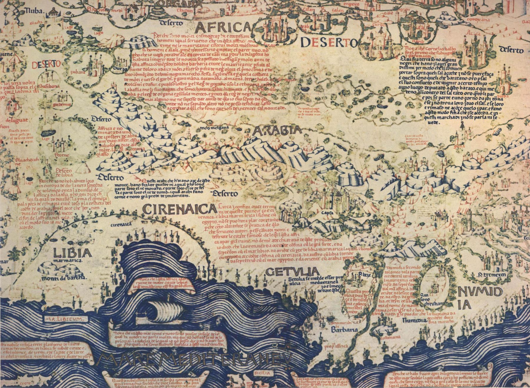
2 · The Fra Mauro map — a detail: North Africa, Arabia and the Mediterranean.
Maker: Fra Mauro, San Michele in Isola, Venice, with Andrea Bianco · Date: c. 1450–1459 (the surviving map is dated by its own record to 1459–1460); the detail reproduced here is sector XXIII of the map · Title: the Fra Mauro world map (mappamondo) · Source: Biblioteca Nazionale Marciana, Venice, via Wikimedia Commons — public domain, verified on the file page, 2026-10-28.
What it shows: the map’s method on its face — south at the top, the Mediterranean along the foot, and the land covered in the maker’s own long notes, weighing the ancient authorities against the reports of travellers, region by region: a world map that argues with its sources in writing, where the reader can check the argument.
What it does not show: measured coastlines. Nothing on the sheet was surveyed; its Africa and Arabia are the shape testimony gave them, strong where Venetian trade ran and conventional where it did not — and its maker, to his credit, often writes exactly that in the notes.
A period document: borders and names are its maker’s, not today’s.
§4 — A NEW CONTINENT GIVEN A NAME IN PRINT: WALDSEEMÜLLER, 1507
DOCUMENTED. In 1507 a small circle of humanists at Saint-Dié, in the Vosges, issued the most consequential map of the age: Martin Waldseemüller’s Universalis cosmographia, a wall map in twelve woodcut sheets, printed with the circle’s little book proposing that the new continent across the Atlantic be named for Amerigo Vespucci: America. It is the first document known to carry that name. The map holds two authorities at once — Ptolemy’s frame, named first in its own title, and the Portuguese and Spanish voyage reports of the previous fifteen years — and the reports win the west: the new lands are drawn as a separate continent, washed by ocean on their far side, years before any European had seen the Pacific or sailed around the world. Their interior is near-empty: an honest blank inside a confident outline. Within a few years Waldseemüller himself withdrew the name in later work — but print had done what print does. The name and the continent stayed on Europe’s maps, beyond recall. That is the print age’s lesson, and 1507 is where the maps learn it.
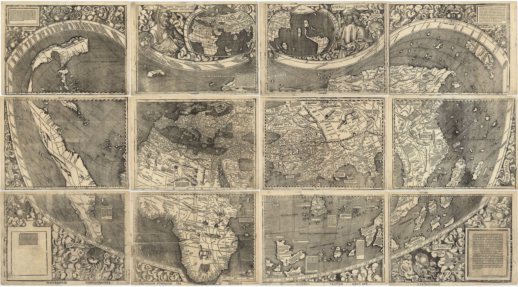
3 · Universalis cosmographia — the map that named America.
Maker: Martin Waldseemüller, Saint-Dié · Date: 1507; the copy reproduced here is the sole surviving copy of the 1507 printing, in twelve sheets shown joined · Title: Universalis cosmographia secundum Ptholomaei traditionem et Americi Vespucii aliorumque lustrationes · Source: Library of Congress, item 2003626426, via Wikimedia Commons — public domain, verified on the file page, 2026-10-28.
What it shows: the whole world as 1507 could state it — Ptolemy’s frame filled with the new voyage reports: the Atlantic crossed, the new continent drawn separate from Asia with ocean beyond it and the name AMERICA lettered on its southern part, Africa rounded, Asia’s east coast still Polo’s.
What it does not show: the Pacific as anyone had seen it — no European had; the ocean west of America is inference, the new continent’s coasts are part report and part reasoning, and its interior is the blank of a land no report had yet crossed.
A period document: borders and names are its maker’s, not today’s.
§5 — THE ATLAS IS BORN: MERCATOR AND ORTELIUS
5.1 A map drawn for sailors (1569)
DOCUMENTED. Gerardus Mercator’s world map of 1569 — its title says “new and enlarged description of the earth, corrected and adapted for the use of navigators,” in eighteen sheets — solved the sailor’s oldest problem. A course steered at a constant compass bearing is a curve on the globe and on every ordinary chart. Mercator spread his parallels by a precise rule so that every such course becomes a straight line a ruler can draw. The price is paid openly, in the geometry itself: lands swell toward the poles, and the poles can never be shown at all. The projection was adopted slowly at sea and within a century was the standard of marine charts — a map that declares, in its construction, what it is for and what it sacrifices. No image of the 1569 wall map is placed in this class: none stands downloaded at the Maps Programme’s standard in this pass, and the map is taught from the record, not from an unverified picture.
5.2 The compiler who printed his sources (1570)
DOCUMENTED. The next year, in Antwerp, Abraham Ortelius published the Theatrum Orbis Terrarum (20 May 1570) — uniform sheets with text, bound as a book, and counted the first modern atlas. Its revolution was the apparatus. Ortelius printed his authorities: the Theatrum carries his Catalogus Auctorum, a list of the mapmakers whose work he had used — the first bibliography of cartography — so a reader could weigh every sheet by its sources. For his Tartary sheet, the first devoted to that region alone, his materials were Giacomo Gastaldi’s maps of Asia, themselves compilations of the travellers; the traveller literature — Marco Polo, with Carpini and Rubruck behind him; for the west, Anthony Jenkinson’s map of Russia (1562), the fruit of a journey down the Volga, across the Caspian and to Bukhara made in person; and, for the Arctic coast, the Northeast Passage reports then coming in. The sheet shows its seams openly: a speculative Arctic coastline, a Japan of Polo’s imagining, Polo’s kingdoms lettered as if surveyed because his sources lettered them so. His successor Hondius wrote of his own continuation of that sheet what stands for the whole method — that he had worked from the best descriptions available, conceded the result described a vast and little-known country, and asked pardon until a better map was found. A compiler printing his authorities and his gaps on the same sheet: the atlas age’s signature.
5.3 The Tartary sheets — this class’s linked apparatus
DOCUMENTED — the apparatus, described as it stands. Ortelius’s Tartary sheet and its three successors stand captioned in full on this strand’s maps plate: The Maps of Tartary — Four Period Maps, 1570–1806 — Ortelius 1570, Delisle 1706, Vaugondy’s Asia 1757, Cary 1806 — worked through as a class in The World of the Maps — Tartary as the Geography Books Knew It. Read there, the four sheets carry this class’s §5.2 finding between them: read whole, each map subdivides the region it names, and the compiler’s label is a portrait of the compiler’s knowledge, not of a state.
§6 — THE DISCIPLINE OF THE BLANK SPACE: DELISLE
DOCUMENTED. Guillaume Delisle of Paris made the next discipline: refusal. Trained in astronomy, geographer to the king, Delisle rebuilt maps from astronomical observations — points whose latitude and longitude were measured, not inherited — and where observation and reliable report ran out, he left the paper blank. His map of Canada (1703) was the first to place that country at its correct latitude and longitude, and its empty north-west, where other makers drew conjectured seas and passages, is the point of it. His Carte de Tartarie (1706, second sheet on the plate linked at §5.3) states its evidence in its own title: drawn on the relations of several travellers of different nations, and on some observations made in that country. The blank is a knowledge-claim of the highest order — this is where knowledge ends, said in ink, in public, at the cost of a less splendid sheet. Delisle himself was corrected in his turn: his Pacific shore of Asia was redrawn within a generation by Bering’s voyages of 1728 and 1741, by the same standard he had set. But the discipline held, and became cartography’s: what a mapmaker refuses to draw is also knowledge.
§7 — THE EMPIRE MAPS ITS OWN STEPPE: THE RUSSIAN ATLASES
DOCUMENTED. Peter the Great ordered a survey of his whole empire in 1721, and the compilation fell to Ivan Kirillovich Kirillov, a surveyor of the Senate Chancellery who received the incoming district surveys and worked them by the new European methods. His projected Atlas of the Russian Empire (from 1734) planned three volumes of 120 maps; he prepared 37, of which 32 were printed, and few sets survive. His general map of the Russian Empire (1734) is the first scientifically made map of Russia printed in Russia: the empire whole, its coasts and river systems on more accurate lines — carrying the first printed results of Bering’s First Kamchatka Expedition, and the first appearance of any part of Alaska (St. Lawrence Island) on a printed map. Under the shared European label of the day it mapped “Muscovite Tartary” with its capital at Tobolsk — a Russian cartographer naming his own empire’s steppe in the common geographical language, from inside it. Kirillov died in 1737; the St Petersburg Academy’s Atlas Russicus (1745), directed by Joseph-Nicolas Delisle — Guillaume’s brother, invited to Russia for the purpose — completed the pass on instrument surveys and astronomical observations. The steppe did not become known when outsiders renamed it. It became known when it was measured, by named men, in maps any reader could check. No image of Kirillov’s atlas is placed in this class: surviving sets are rare, and no copy was verified to the programme’s standard in this pass — the atlas is taught from the record, and the gap is owed, not filled.
§8 — THE LABEL’S LONG LIFE: THE FRENCH SCHOOL, CARY AND TALLIS
DOCUMENTED. Compilation and surveying ran side by side for a century, and the old regional names lived on in the compiled atlases long after the surveyors had better ones. D’Anville, the French school’s master compiler, issued his Asia in two parts (1751–52), working from the Russian and Chinese maps. Robert de Vaugondy’s Atlas Universel (plates drawn c. 1750, published 1757) drew its Asia principally on the maps of Russia, of China and of Chinese Tartary, and lettered GRANDE TARTARIE across the whole north — a regional wash laid over lands the same sheet subdivides into Russian provinces, Qing dominions and independent khanates. John Cary’s New Map of Chinese & Independent Tartary (1806) shows the label in its last surveyed generation, the treaty border ruled between the Russian and Qing shares. And Tallis’s Independent Tartary (1851), with its vignettes of the region’s peoples and cities, is the label’s last stand in the popular atlases. None of these sheets was hidden or rare: the label’s whole life is one of the best-attested runs in cartographic history, held openly in the world’s libraries — which is why the maps can be set side by side, as this strand sets them, and read.
§9 — THE SURVEYS: KNOWLEDGE REPLACING THE PLACEHOLDER
DOCUMENTED. What retired the old names was not decree but measurement, done publicly by named surveyors and published for anyone to test. States founded survey offices and triangulated their territories: the Cassini family’s survey of France, four generations of one family, published in 182 sheets across 1744–1815; Britain’s Ordnance Survey, founded 1791. At the pattern’s grandest scale stands the Great Trigonometrical Survey of India: begun on 10 April 1802, when Colonel William Lambton measured his first baseline near Madras; carried north by George Everest from 1823; its Great Arc of triangulation running some 2,400 kilometres from Cape Comorin to the Himalayas; its computers announcing in 1856 that Peak XV — the peak that bears Everest’s name — was the highest measured mountain on earth, its height computed from measured angles by men who never stood on it. The survey’s record is full of fevers, broken instruments and the names of the men, Indian and British, who did the work. Measurement at this scale is a human archive, not an anonymous one.
DOCUMENTED. A placeholder name has work to do only while the ground is unmeasured. “Tartary” named, honestly, the not-yet-surveyed interior between the Caspian and the Pacific; as triangulation, astronomical fixing and surveyed gazetteers accumulated, the work passed to the names of the measured parts — Siberia, Mongolia, Manchuria, Turkestan, and “Central Asia,” Alexander von Humboldt’s term of 1843. The old word dissolved into its contents in print, in the open, over roughly a century: whole in Tallis in 1851, gone as a country-heading from the great atlases by the century’s end, and surviving where it was always real — in the Tatar peoples, in Tatarstan, and in the Strait of Tartary, which keeps the name on charts today. Knowledge did not erase the placeholder. Knowledge replaced it, sheet by dated sheet — and the trail of the replacement is itself the archive.
§10 — THE CLOSE: WHAT A MAP’S HONESTY TEACHES
DOCUMENTED — the method, one last time. Five centuries of maps teach one reading skill, and it is the skill this whole strand has used, on every document it has opened. A period map is a portrait of its maker’s knowledge. Its certainties mark where its age had sailed, walked, traded or measured. Its decorations mark what its age valued. Its honest edges — Polo’s kingdoms lettered as fact because the sources lettered them so, Ortelius’s printed authorities and conceded gaps, Delisle’s blanks, the near-empty interior of Waldseemüller’s new continent — mark where its knowledge ended; and a map that marks that line truthfully can be trusted on both sides of it. The maps were drawn wrong in places, in good faith, from the best reports going. They were corrected the same way, in the open, by better reports and then by measurement. Nothing in the five centuries was served by pretending to know more. The world got onto paper the way knowledge gets anywhere: gathered from the people who had been there, confessed where it was thin, and replaced — never erased — when the ground itself was finally measured.
Sources
Period works named in the text: the portolan-chart tradition (Carte Pisane, late 13th century, and its successors) · Catalan Atlas (1375), attributed to Cresques Abraham · Fra Mauro world map (c. 1450–1459) · Waldseemüller, Universalis cosmographia and the Cosmographiae Introductio (1507) · Mercator, Nova et aucta orbis terrae descriptio ad usum navigantium (1569) · Ortelius, Theatrum Orbis Terrarum (1570), with the Catalogus Auctorum and the Tartary and Russia sheets · Jenkinson’s map of Russia (1562) · Gastaldi’s maps of Asia (1548–1561) · Delisle, Carte du Canada (1703) and Carte de Tartarie (1706) · Kirillov, general map of the Russian Empire and the projected Atlas of the Russian Empire (1734) · the St Petersburg Academy’s Atlas Russicus (1745) · d’Anville, Asia in two parts (1751–52) · Robert de Vaugondy, Atlas Universel (1757) · Cary, A New Map of Chinese & Independent Tartary (1806) · Tallis, Independent Tartary (1851) · the Cassini survey of France (1744–1815) · the Great Trigonometrical Survey of India record (1802–1871).
Modern works named in the text: Alexander von Humboldt, Asie centrale (1843), for the replacement term “Central Asia” · Leo Bagrow’s history of Russian cartography, for Kirillov’s atlas and general map · the holding collections’ records for the three placed maps — Bibliothèque nationale de France (the Catalan Atlas), Biblioteca Nazionale Marciana, Venice (the Fra Mauro map), Library of Congress (the Waldseemüller map, item 2003626426) — each verified on its Wikimedia Commons file page, 2026-10-28, under the Maps Programme register.
Read beside this class: The Maps of Tartary — Four Period Maps, 1570–1806 · The World of the Maps — Tartary as the Geography Books Knew It · The Steppe World · The Table of Nations · The Chronology — The Whole History in Order of Time.
Record: THE_MAPPING_OF_THE_WORLD_2026-10-28.md (study_materials/world_history), with the Maps Programme register — MAPS_PROGRAMME_REGISTER_2026-10-28.md — for the placed maps’ captions and hashes, and the Tartaria research file, tartaria-the-land-and-the-claim.md (research/tartaria), §2.2 and Addendum A.4, for Ortelius’s sources.