Indigenous · History Classes · Grades 10–13 · College · University
The Maps of Tartary — Four Period Maps, 1570–1806
History Class · Maps plate · Level band: Grades 10–13 · College · University
English edition — the language editions of the history classes are outstanding and will follow the site’s translation pattern; none is fabricated here.
How to read a period map
Class: RESEARCH — the strand’s method. A period map is a document of its maker’s knowledge, not a photograph of the earth. Its coastlines are only as good as the reports its maker had; its colours are a labelling geographer’s conveniences, not governments; and its blank or fanciful corners are evidence too — of what its maker did not know. The four maps below span the whole atlas life of one word, Tartary: its first sheet of its own in 1570, its scholarly redrawing in 1706, its French-school fullness in 1757, and its last surveyed generation in 1806. Between them they show a label being born, worked, and — within two generations of the last of them — retired, in print, in the open.
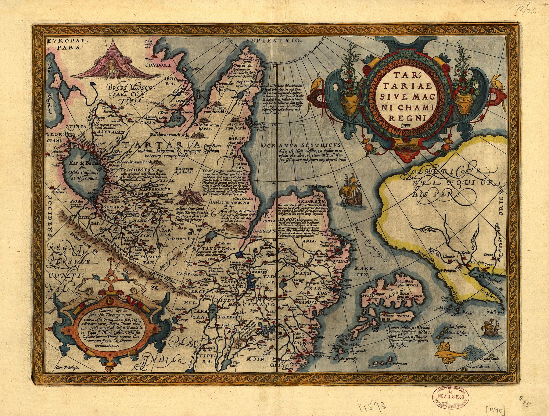
1 · Tartary, or the Kingdom of the Great Khan.
Maker: Abraham Ortelius, Antwerp · Date: plate first published 1570 in the Theatrum Orbis Terrarum; the copy reproduced here is the Library of Congress impression of the 1603 edition · Title: Tartariae sive Magni Chami Regni typus · Source: Library of Congress, item 83690086, via Wikimedia Commons — public domain, verified on the file page, 2026-10-28.
What it shows: the first atlas sheet devoted to Tartary alone — the Great Khan’s realm and its successor lands from the Caspian to the Pacific, lettered with the peoples, camps and kingdoms as Antwerp knew them in 1570; the title itself states the label’s meaning.
What it does not show: a surveyed north-east. The coast beyond the Lena and any passage toward America are drawn from report and hope; the peoples are lettered across open country because no one had measured it, and the sheet does not mark where knowledge ends and report begins.
A period document: borders and names are its maker’s, not today’s.
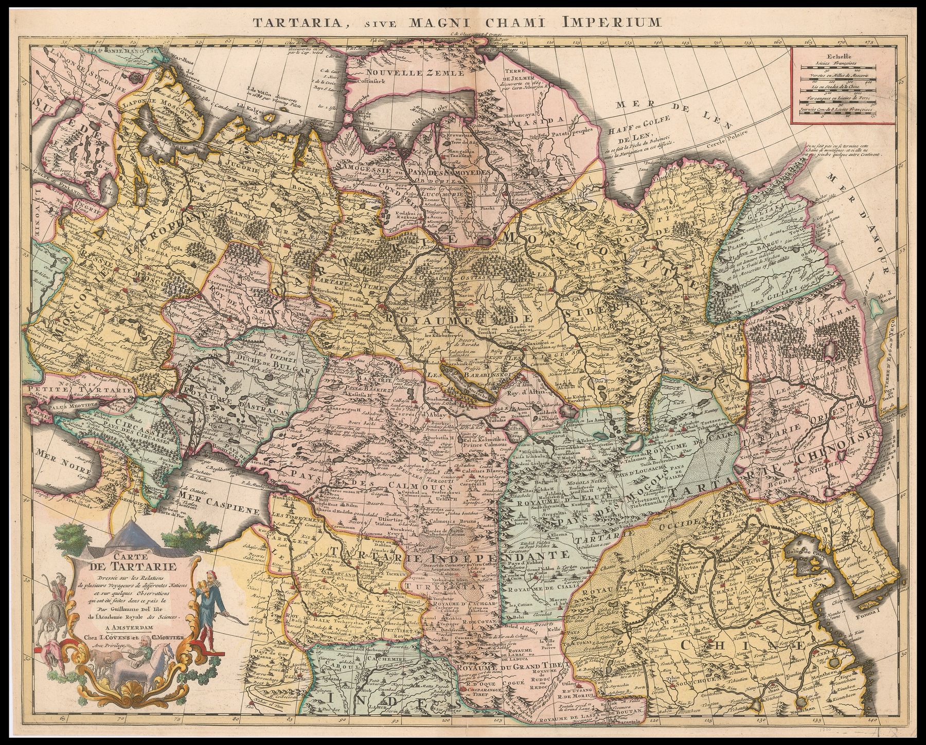
2 · Carte de Tartarie.
Maker: Guillaume Delisle, Paris; the impression reproduced here is the Amsterdam reissue by Covens & Mortier, whose imprint stands in its cartouche · Date: map first published 1706; the reissue kept its geography unchanged · Title: Carte de Tartarie, headed Tartaria, sive Magni Chami Imperium · Source: National Library of Israel, Eran Laor Cartographic Collection, via Wikimedia Commons — public domain, verified on the file page, 2026-10-28.
What it shows: Tartary redrawn as Delisle’s title promises — on the relations of several travellers of different nations, and on some observations made in that country: Siberia with its rivers and Tobolsk, the khanates of the steppe, and Chinese, Muscovite and Independent Tartary distinguished on one crowded, working sheet.
What it does not show: the region whole. Read closely, the sheet is a crowd of parts — kingdoms, peoples, deserts, caravan roads — not one state; and its Pacific edge is Delisle’s of 1706, drawn before Bering’s voyages (1728, 1741) fixed the strait between Asia and America: the north-east shore would be redrawn within a generation.
A period document: borders and names are its maker’s, not today’s.
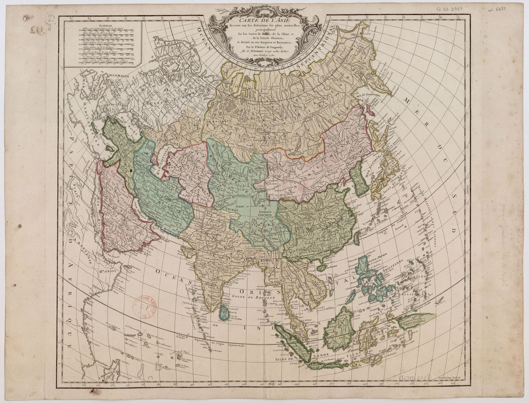
3 · Carte de l’Asie.
Maker: Didier Robert de Vaugondy, engraved by Guillaume-Nicolas Delahaye · Date: Atlas Universel, 1757 (plate drawn c. 1750) · Title: Carte de l’Asie · Source: Bibliothèque nationale de France (Gallica, btv1b8592764r), via Wikimedia Commons — public domain, verified on the file page, 2026-10-28.
What it shows: all Asia at mid-century, drawn — its full title says — principally on the maps of Russia, of China, and of Chinese Tartary: GRANDE TARTARIE lettered across the whole north in the French-school manner, the map of this family that circulates today in the Tartaria literature.
What it does not show: one Tartarian empire. The broad lettering is a regional label laid over lands the same map subdivides and names severally — Russian provinces, Qing dominions, the independent khanates — and its interior is compilation, not survey: its maker worked in Paris from other men’s maps.
A period document: borders and names are its maker’s, not today’s.
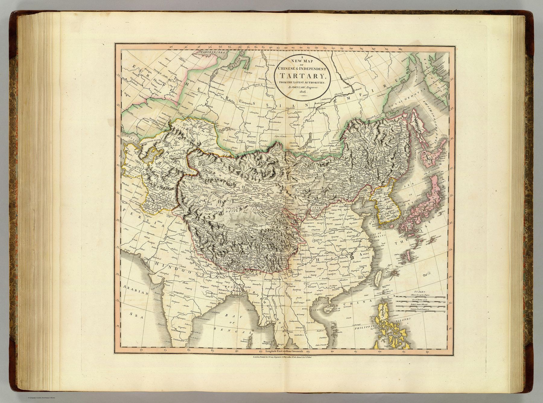
4 · A New Map of Chinese & Independent Tartary.
Maker: John Cary, London · Date: 1806 · Title: A new map of Chinese & independent Tartary, from the latest authorities · Source: David Rumsey Map Collection copy (image 1657.049), via Internet Archive / Wikimedia Commons — public domain, verified on the file page, 2026-10-28.
What it shows: the label in its last atlas generation — Chinese Tartary and Independent Tartary drawn as surveyed regions, the Kyakhta-treaty border between the Russian and Qing shares ruled across the north, the khanates in their places as going concerns of the year 1806.
What it does not show: “Independent Tartary” as a country. It is a geographer’s remainder-label for the khanates standing between two empires; and within two generations of this sheet the word Tartary itself had left the atlases — retired by the surveyors, in print, as the Tartaria research file records (§2.7).
A period document: borders and names are its maker’s, not today’s.
Where this plate belongs
Class: RESEARCH — placement note. This plate was prepared for the Tartaria class page under the Maps Programme register’s foundation scope, and stood uncarded on the senior index in that pass. The class page now stands — The World of the Maps — Tartary as the Geography Books Knew It, built 2026-10-28 under the owner’s completion direction — and this plate is its visual apparatus, linked from its §2 and carded with it on the senior index. The plate remains a page of its own, so the four maps can be read at full size; its captions stand unchanged, exactly as written to travel.
Record: Maps Programme register — MAPS_PROGRAMME_REGISTER_2026-10-28.md — with the Tartaria research file, tartaria-the-land-and-the-claim.md (research/tartaria), §§1.2, 2.x and 3.x for the maps’ documentary line and the claim made over them.